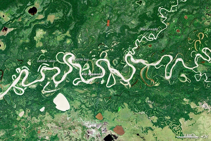
Rivers are shaped by the geography around them and, through their own flow and movement, change and shape the landscape around them. (Related: How Oxbow Lakes Form)
Rivers haven’t always flowed in the same directions as they do today. Rivers have a tendency to change with the landscape as mountains are formed, sediment is deposited, and landforms drift apart. Rivers that were once dominant parts of the landscape are now gone, dried and left with few markers of their existence.
Rivers have a tendency to change, as we’ve seen. Rivers that continue to flow can sometimes reverse their directions due to natural and man-made factors including erosion, natural disasters, and city planning for a variety of reasons.
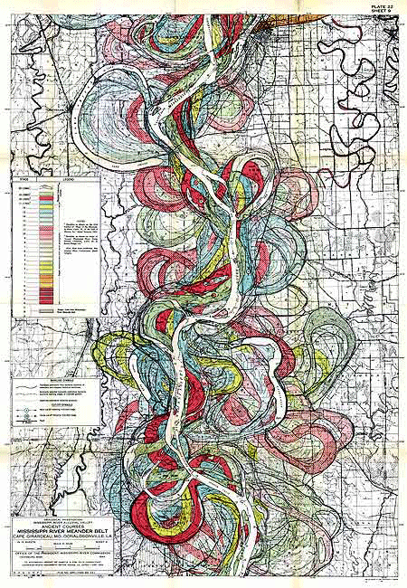
Some rivers that have changed for natural reasons include the Amazon and the Mississippi, bringing them into the group of many rivers that have switched direction (and sometimes switched again).
Amazon River Flow Over Time
The theory of how the Amazon River was born begins millions of years ago when a collection of rivers in what we now know as the Amazon Basin reversed their course and became a larger river. This change was brought about by erosion and the growth of the Andes Mountains in the western part of South America.
Prior to the massive growth of the Andes water flowed in a westerly direction towards a group of lakes that steered the flow north to be deposited into the Caribbean Ocean.
These lakes put a lot of pressure on the Earth’s crust, but tectonic movement eventually evened out the lakes and created a large wetland area that also eventually disappeared because the Andes continued to grow upwards and outwards. The changes that this crust and tectonic movement created helped redirect the water movement in South America in different ways and eventually reversed the flow of many of the rivers in an easterly direction towards the Atlantic Ocean as opposed to the Pacific Ocean or Caribbean Sea.
Erosion also played a major part in the flow change of the Amazon. The growth of the Andes increased the chances of rainfall which produced more erosion coming off of the mountain range, prompting the buildup of sediment faster than the rivers could wash it away. This was a major contributing factor to the course of the Amazon River flowing backwards.
Changing directions of the Wayombo River
The Wayombo River in Suriname flows over flat terrain with minimal elevation change. The river splits in the central part of the country, creating a bifurcation where water can take one of two very different paths. From its upper reach, known as the Boven Wayambo, the river can either flow west toward the Nickerie River or east toward the Coppename River. Both of these rivers ultimately drain into the Atlantic Ocean, but which direction the Wayombo takes depends on a mix of natural conditions and human interventions.
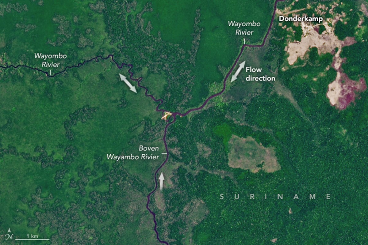
Seasonal rainfall plays a key role in determining the river’s course, but so do manmade structures. In particular, a lock near the connection with the Nickerie River is used to divert water westward to support rice farming in that region. Without this infrastructure or during different conditions, the Wayombo may instead flow east. This dynamic routing makes it one of the rare rivers capable of reversing or redirecting its course depending on current hydrological and management pressures. Ongoing observations from satellite missions such as SWOT (Surface Water and Ocean Topography) are helping researchers better track and understand the behavior of such bifurcating and unpredictable river systems.
Mississippi River Reversed Flow After Hurricane Isaac in 2012
A second river that has seen a reversal of flow is the Mississippi River after Hurricane Isaac in 2012. Although this backwards flow wasn’t permanent- the situation only lasted for about 24 hours- the river showed an increase of water to the extent that it was flowing faster backwards than it does forwards on average.
The amount of water that was dumped on the Mississippi River during Hurricane Isaac was enough to increase the flow of water into the mouth of the Mississippi. The water that was pushed into the Gulf of Mexico from the hurricane surged into the Mississippi River delta faster than the water coming out the Mississippi could hold it back.
The Mississippi River also reversed during Hurricane Katrina in 2005. Rivers flowing backwards is a common occurrence during hurricanes alongside coastal routes around the world.
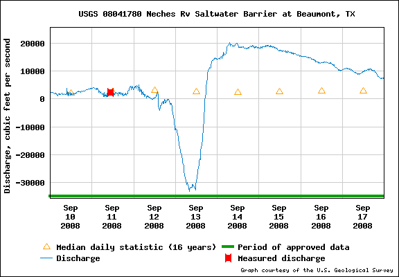
This streamgauge in Beaumont, Texas shows how the water velocity slows and then reverses as Hurricane Issac moves onshore.
Related: Hurricane Laura Made This River Flow Backwards Temporarily
Man-Made River Reversal in Chicago
Some man-made factors that influence the course of a river include drought, city planning, purposeful reversal, and objects like dams and locks. The Chicago River is one instance of many of these man-made factors causing a reversal in the flow of a river.
A drought that is currently affecting that area of the world is threatening to reverse the flow of the Chicago River from its current drainage into the Mississippi River to its original drainage into Lake Michigan. A series of locks keep the river from reversing direction itself for the time being.
The river first flowed into Lake Michigan instead of the Mississippi River in the late 1800s but was reversed when contaminated drinking water threatened the populations of people who relied on that source for clean drinking water and sanitation purposes.
Rivers have changed their flows throughout the course of history because of a few natural and man-made reasons. Although the reversal of river flows can seem dramatic, many rivers over the course of history have flowed backwards for a variety of reasons.
References
Geological Society of America. (2006, October 25). Amazon River reversed flow. ScienceDaily. https://www.sciencedaily.com/releases/2006/10/061025183901.htm
Liang, W. (2025, March 2). When rivers take a weird turn. NASA Earth Observatory. https://www.earthobservatory.nasa.gov/images/154394/when-rivers-take-a-weird-turn
WTTW Chicago. (2018, September 4). How Chicago reversed its river: An animated history [Video]. The Chicago Tour with Geoffrey Baer. https://interactive.wttw.com/chicago-river-tour/how-chicago-reversed-river-animated
Perkins, S. (2014, July 15). Why the Amazon flows backwards. Science. http://news.sciencemag.org/earth/2014/07/why-amazon-flows-backward
Sacek, V. (2014). Drainage reversal of the Amazon River due to the coupling of surface and lithospheric processes. Earth and Planetary Science Letters, 401, 301–312. https://doi.org/10.1016/j.epsl.2014.06.022
Shephard, G. E., Müller, R. D., Liu, L., & Gurnis, M. (2010). Miocene drainage reversal of the Amazon River driven by plate–mantle interaction. Nature Geoscience, 3(12), 870–875. https://doi.org/10.1038/ngeo1017
Soniak, M. (2013, January 25). Has a U.S. river run backwards before? Mental Floss. http://mentalfloss.com/article/33572/has-us-river-run-backwards
Sowby, R. B., & Siegel, A. C. (2025). Unusual drainages of the Americas. Water Resources Research, 61(2), e2024WR039824. https://doi.org/10.1029/2024WR039824
U.S. Geological Survey. (2012, August 29). Mississippi flows backwards due to Isaac. https://www.usgs.gov/newsroom/article.asp?ID=3387&from=rss#.VF7aX76Te3V
This article was originally written on November 24, 2014 and has since been updated.


